New Westport Master Plan Calls for Shorter Buildings, Wider Sidewalks
Published May 28th, 2019 at 12:15 PM
By Kevin Collison
A new master plan intended to guide the future development of Westport over the next 20 years proposes height restrictions along its primary streets, wider sidewalks and potential historic designations for nearby neighborhoods.
The Westport District Master Plan is in response to concerns two years ago over two large apartment proposals and follows 18 months of work by a steering committee representing key Westport constituencies.
“We’d love to see this go forward to protect what we see is special about Westport,” said Ken Kimbrough, executive director of the Westport Regional Business League.
Kimbrough was one of several people speaking in support of the master plan prepared by Gould Evans at a City Plan Commission meeting last week.
The commissioners voted unanimously to recommend approval to the Kansas City Council. It’s expected to be considered by the Council Planning, Zoning & Economic Development Committee June 5.
While the Westport master plan is advisory, it ultimately could be the basis of mandatory regulations for Westport including a potential special overlay district, spot rezoning, and historic designations for buildings and districts.
“We feel what you see before you is a good compromise that preserves what’s good about Westport and allows it to grow and change,” said Lisa Briscoe, executive director of Historic Kansas City, the city’s primary historic preservation organization.

Concerns over two large apartment developments, including the six-story Opus Development project being built at Westport Road and Broadway, launched the Westport master plan process. (Rendering from Opus Development)
It was concerns by Historic KC, City Councilwoman Kathryn Shields and others over two big apartment proposals in 2017 that prompted the master plan.
While Westport always has been considered one of the city’s most popular historic districts, it had no comprehensive guidelines to evaluate new development.
One of the apartment developments, a 256-unit, six-story building at the southeast corner of Westport Road and Broadway currently is being built by Opus Development Group.
The other, Westport Terrace at Manor Square, remains in the development stage. It calls for 205 apartments and a 120-room hotel in seven- and nine-story buildings at the north end of the existing Manor Square garage between Mill Street and Pennsylvania Avenue.
A temporary moratorium on additional development was established by the City Council at the request of Shields to allow time to inventory Westport buildings and prepare a master plan.
The height restrictions proposed in the new master plan would limit future development along the core streets of Westport to three-stories.
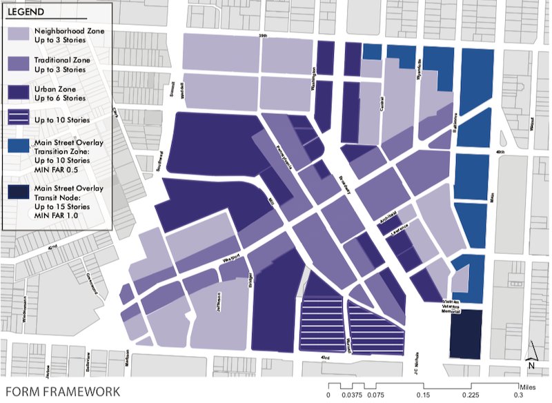
The proposed Westport master plan would limit development height on Westport Road and Pennsylvania Avenue to three stories. (Image from Gould Evans)
That limit would be applied to Westport Road between Southwest Trafficway and Baltimore, and Pennsylvania between 40th Street and Mill Street. That three-story restriction also would apply to surrounding neighborhoods.
Buildings up to six-stories would be allowed outside those areas, and property controlled by St. Luke’s Hospital on the south edge of Westport along 43rd Street, now employee parking lots, could be developed up to 10 stories.
Development that respects the plan’s height restrictions also is encouraged on the many parking lots within the boundaries of Westport.
Another master plan recommendation concerns what it calls public spaces, which in the case of the tightly contained, 176-acre Westport community, primarily means its sidewalks and streets.
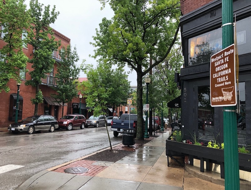
The new master plan calls for wider sidewalks along Westport Road and Pennsylvania Avenue.
The new master plan recommends that sidewalks be widened and vehicle traffic lanes be restricted throughout much of Westport. It also suggests a public square to be developed at the intersection of Westport Road and Mill Street.
The plan calls for sidewalks along Westport Road from Southwest Trafficway to Baltimore be widened to 15 feet where possible and travel lanes remain at 10-feet. It recommends improved pedestrian amenities including trees, benches and trash receptacles.
For Pennsyvlania, it recommends expanding sidewalks to 10-feet, maintain the 9-foot travel lanes and improve pedestrian amenities including adding benches.
Where Broadway passes through Westport, it calls for the busy artery to evolve toward more balanced, multiple modes of transportation including bicycles. it advocates a minimum of 10-foot sidewalks and traffic lanes consistent with its boulevard status.
The plan also suggests the intersection of Broadway, 40th Terrace and Washington Street be reconstructed to narrow the street.
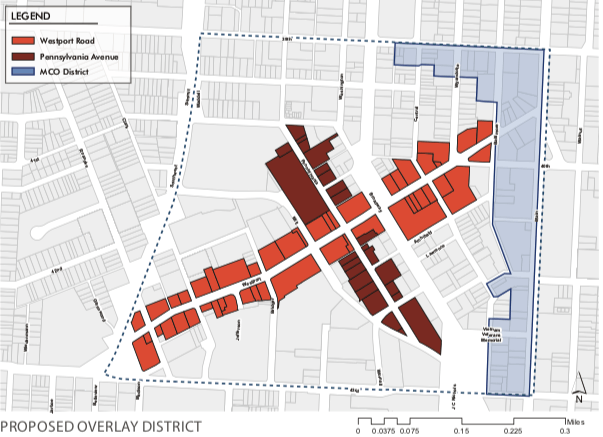
The master plan suggests a “Special Character Overlay District” be created for the core of Westport. (Map by Gould Evans)
The plan for Mill Street calls for extending access to Dr. Jeremiah Cameron Park, a small green space northwest of 43rd Street and Broadway, by building a bicycle/pedestrian path from where the street dead ends near its intersection with Pennsylvania.
As for historic preservation, a controversial subject particularly in the commercial areas of Westport, the master plan took a more cautious approach.
Properties within a formal historic preservation district have strict limits about altering their exterior appearance, a restriction that many business owners have resisted.
The proposed master plan documents Westport properties currently designated as historic and suggests additional properties and districts that could be eligible for historic designation.
It supports formal designation for any historic building or district, but recommends priority be given to creating historic districts for two residential neighborhoods, Whittier Place and South Roanoke.
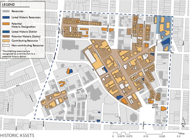
The master plan includes an inventory of historic properties and districts in Westport. (Map by Gould Evans)


